Grant by King Edgar to Aethelwold, bishop; grant of 3 mansae at Madeley, AD 975. The boundary clause only, identifying the boundary with Wrinehill:
Old English (Anglo-Saxon) text [from Della Hooke, The landscape of Anglo-Saxon Staffordshire: the charter evidence, 1983, pp. 106.] Reproduced by kind permission of the Centre for Continuing and Professional Education, University of Keele.
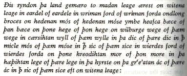
Translation [Based on: Della Hooke, The landscape of Anglo-Saxon Staffordshire: the charter evidence, 1983, pp. 106-
Reproduced by kind permission of the Centre for Continuing and Professional Education, University of Keele.
These are the boundaries of Madeley; first to the clearing of the counsellors; from the clearing of the counsellors to the clay-dale; from the clay-dale to wriman [Wrine(hill)] ford; from wriman ford along the brook to Hedena’s moss; fromHedena's moss around hawk batch (stream); from the batch to the hedge; from the hedge to Wilburh's way; from Wilburh's way to the watercress spring; from the spring to the dyke; from the dyke to the great marsh; from the marsh to the watercourse; from the watercourse to wierdes ford; from wierdes ford to the reedy marsh; from the marsh to the heathy clearing; from the clearing to the wooded hillock; to the great oak; from the oak to the watercourse; from the watercourse again to the clearing of the counsellors.
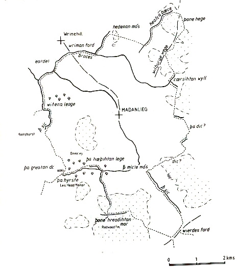
Map of the Madeley boundaries [from Della Hooke, The landscape of Anglo-Saxon Staffordshire: the charter evidence, 1983, pp. 109.] Reproduced by kind permission of the Centre for Continuing and Professional Education, University of Keele.
back to top